A good map is essential to get the most out of your trek to Everest Base Camp. It can help you plan your trek, pace yourself, find interesting points of interest, and even identify mountains. Here is a quick rundown of maps, both paper-based and digital, suitable for the Everest Region:
Maps of Everest Region by Himalayan Map House

Himalayan Map House is synonymous with tourist maps in Nepal. They have a large number of titles and are very competitively priced. Once in Kathmandu, you will see their maps in every book shop in Thamel. They have 14 different titles for the Everest Region: from the famous Everest Base Camp Trek to the unheard-of Monastery Circuit Trail. Hell, they even have a Chinese language version of the map.
And their reputation is well deserved. They are pretty accurate, easy to store, and straightforward to read. Priced anywhere between USD 4-7, maps by Himalayan Map House do not break your heart if drenched by rain.
However, things we do not like about their maps are that they are not laminated and are prone to tearing at the folds. Also, if exposed to the elements, they are good as most paper products are.
The best place to get the physical map for your trek is from Himalayan Map House. You can visit the shop or order through their website. Their contact number and physical locations are listed below:
Contact: 977-1-4244965, 977-1-4231220
- The Map Shop, Jyatha Road, Thamel
- Himalayan Book House, Kathmandu Guest House Chowk, Thamel
- Nepal Himalayan Book Sellers, Chhetrapati, Thamel
National Geographic Maps for Everest Region

You can also get the waterproof and tear-resistant map of the Everest Region from the illustrious National Geographic folks for a few dollars more. In addition to the prestige these maps come with, they also have a Nepal map on the backside. Now that can be pretty useful.
For the Everest Region, they have two titles: one for the Everest Base Camp + Gokyo Lakes side and another for the whole of Khumbu Region.
Getting these maps can be difficult if you are in Nepal. As such, we recommend buying them online in your home country. However, before deciding which one to buy, check out the coverage of each map given on their website below.
National Geographic Map of Everest Base Camp Trek- 1:50,000 – USD 14.95- Link
National Geographic Map of Khumbu Region- 1:125,000 – USD 14.95 – Link
Maps of Everest by Great Himalayan Trail

Great Himalayan Trail provides high-quality maps both in digital and physical form. They provide high-resolution digital files in PDF featuring all major trekking trails and places of interest. They provide maps of major areas of Nepal (Everest Region, Dolpo, and Mugu, Mustang, Annapurna, etc.). And they are waterproof and tear-resistant, as all maps should be.
You can order the maps from the Great Himalayan Trail website for USD 10 apiece. They are also available in some book shops in Thamel, like Vajra Books.
Google Maps
When we talk about digital maps, Google Maps is the most used and popular among all the maps. If you are thinking of using it for your Everest Base Camp trek, it is well and good as long as you will not solely depend on it.
For starters, unlike paper maps, digital maps are interactive, and you can get information like time to destination and distance on the fly. You can also switch between satellite view, terrain view, and the default view to better make sense of the world around you. But the best thing about digital maps in general and Google Maps, in particular, is that they provide detailed additional information. Think photos of the area you are interested in, landmarks, traffic, attractions, hotels, ATMs, mountains, and everything else. And all of it is up to date and only gets more accurate the more people using it.
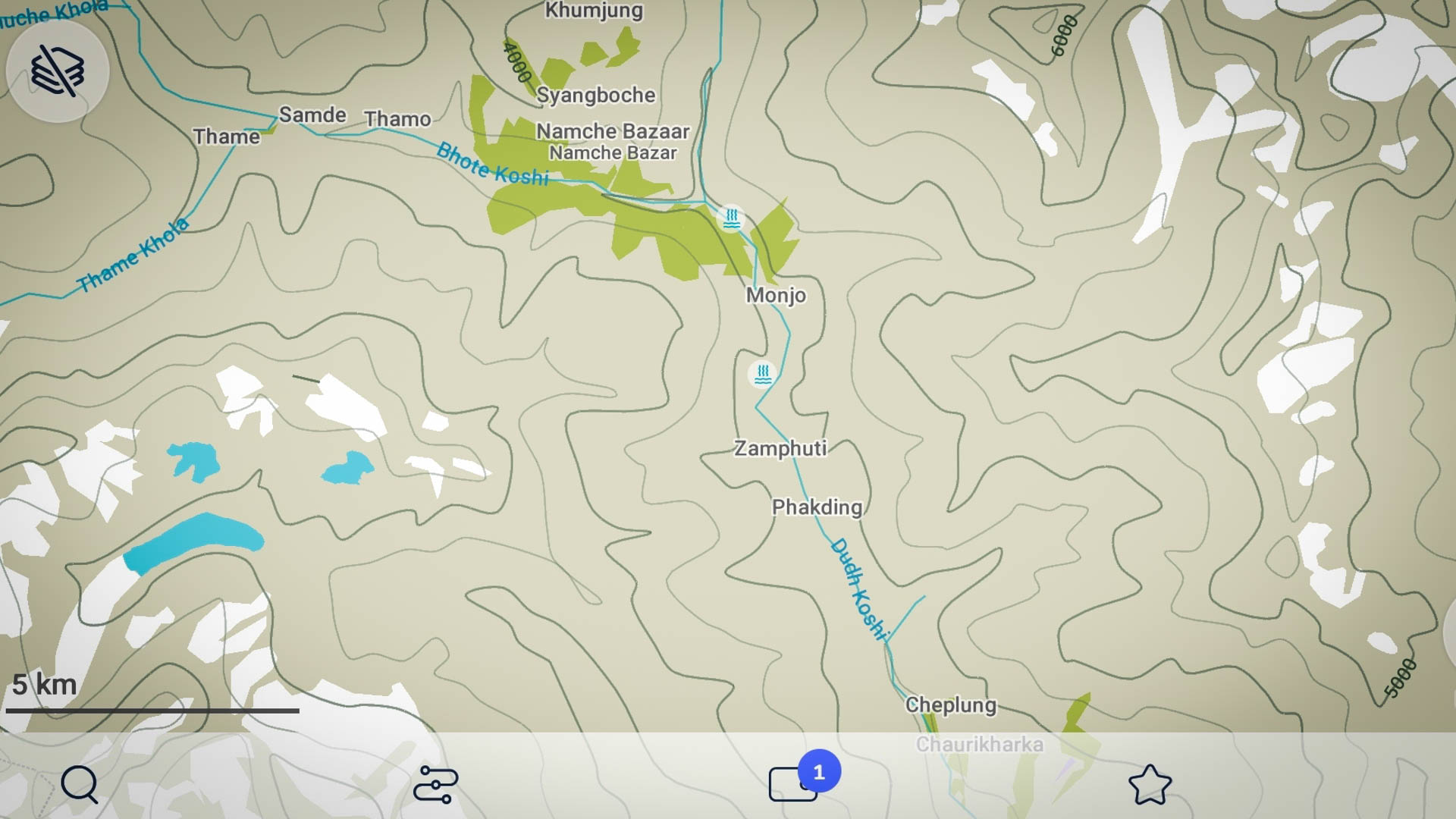
On the flip side, however, Google Maps needs a smartphone, and smartphones need electricity. In many settlements above Namche, electricity can be a premium commodity, and it is best not to depend on it. Also, the offline function of Google Maps is limited, and so is the internet in the Everest Region. Not a good combination. But the thing that we hate the most about Google Maps is that the information has many gaps and is occasionally downright inaccurate in some cases. For example, the trail between Dzongla and Thagnak is missing, and if you try to navigate from Namche to Gokyo, Google Maps will take you past Phortse through the eastern bank of the Dudh Koshi River. Unfortunately, while there is a trail there, you will be hard-pressed to find a place to rest the night on that trail.
Long story short, Google Maps, while good, is pretty limited in its usability as a standalone map for the Everest Base Camp Trek. However, do check out the really cool Street View project Google undertook in Khumbu a few years ago.
MAPS.ME
Another digital map that you can use for your Everest Region Trek is ‘Maps.me’. It is a mobile app for Android and iOS that provides offline maps using OpenStreetMap data. And we absolutely adore this app.
If it were not for the extreme weather and unpredictability of electric supply along the EBC route, we would even go so far as to recommend the app as the standalone map for the EBC trek!
Some of the points we love about the app are:
- You can download it for free for both Android and iOS devices, And nothing beats free.
- It works offline. You download the map one, and you are done!
- The data is based on the excellent OpenStreetMap initiative and is accurate and up to date, especially regarding hiking trails and outdoor routes.
- It has an excellent navigation feature that shows you the altitude profile, provides you transportation options, and of course, gives you turn-by-turn navigation.
- The POI list is vast and is better than anything else available. Hotels, hospitals, monasteries, shops, and bakeries, Maps.me knows them all.
Survey Maps of Everest Region

Topographic maps for Nepal are highly detailed and accurate maps and are published by the Department of Survey. It takes years of effort to compile these maps and are usually the gold standard and the primary data source for commercial maps. But that accuracy can be a double-edged sword as not everyone needs it. Also, while very accurate topographically, these maps are not the most up-to-date regarding points of interest.
You can either buy these topo sheets at a few select online / offline outlets or get the digital copies from the Department of Survey, Nepal, or the MCAAD website.
Google Earth
Google Earth is porn for travelers. While the desktop and web-based versions are great to get a feel of the terrain before you go, the mobile app can be a valuable tool to have on the trail. To help you get the most out of Google Earth, we have compiled a list of places along with their descriptions and route information for popular treks. You can download it here.
Not a Map, but better than a map
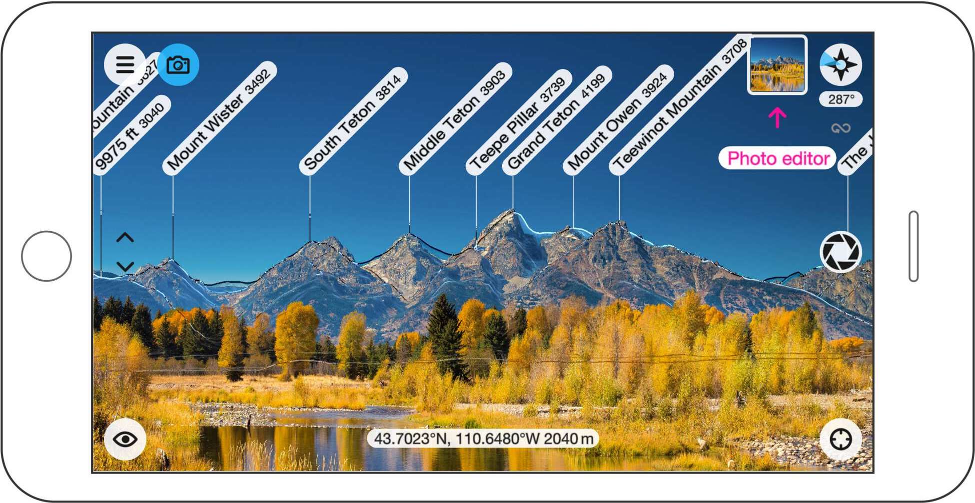
One of the main functions of the map is to find the peaks. Well, thanks to technology, now we have everything at our fingertips. There is an app called Peak Finder that will help you to identify Peaks during your treks. You can get this app on both Android and iOS devices for USD 4.99.
While we understand this isn’t the place for an app like this, we just love this app so much that we couldn’t help.
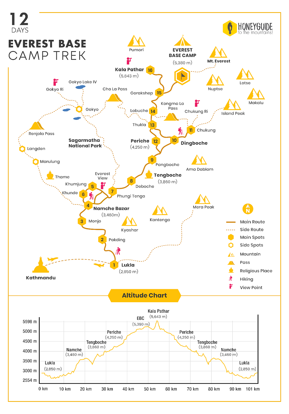
Everest Base Camp Trek Map by HoneyGuide
We have pooled our expertise and content on the Everest Region to create a map/guidebook for the Everest Base Camp Trek. It is however a work in progress and currently works best only with Google Maps. Let us know what you think of it, and please provide us feedback on how we can make it better. Key features are:
- Places are clickable and provide you with details about the place and link to that place’s page in HoneyGuide website. We even have a dedicated pages to even small hamlets like Deboche. No place in Everest is too small for HoneyGuide.
- The trails are clickable and provide you detailed trail descriptions.
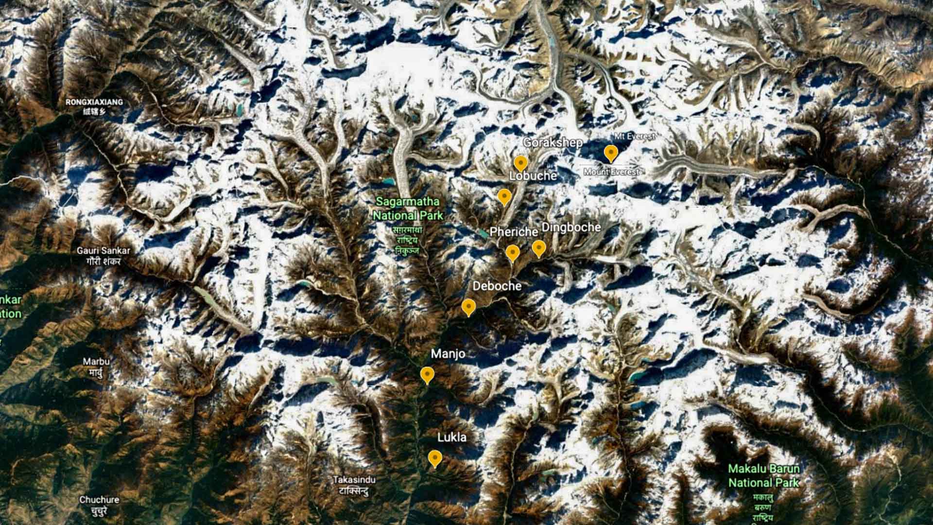
If you are looking for a simple map here is one: